Mormon’s Clues, A New Look At Book of Mormon Geography, 2006 (Internet edition 2001), James Warr
Aside from lacking four bodies of water, Warr exemplifies how blinded one can become when fixated upon a physical model before extracting the internal. Here are several contradictions:
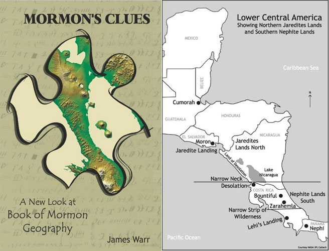
The key to Book of Mormon geography is the narrow neck of land. It is the most important clue that the prophet Mormon left us. (p. 11)
It should be a unique feature which ought to be easily identified, and around which we could assemble the remainder of the geography. Most researchers consider it to be an isthmus that connected the land southward and the land northward. If this geographic feature could be positively identified, it would solve the riddle of Book of Mormon lands, and all else would naturally fall into place. (p. 11)
How did this feature appear to the Nephites? First of all, it’s narrowness would have been observable from the ground. Remember, the Nephites didn’t have access to modern maps or aerial views of landscape, so they described what they could actually see. (p. 11)
Notice how in one breath Warr acknowledges the narrowness from eye level and in the next contradicts:
It could be traversed in 1 to 1.5 days. This would make it approximately 15-40 miles wide (See discussion on distances in chapter 9; see also Alma 22:32; Helaman 4:7). (p. 12)
At one time in Jaredite history, the narrow neck was blocked by a plague of poisonous serpents so that neither man nor beast could pass (see Ether 9:31-34). (This could only occur in a warm climate, with a water barrier on both sides of the narrow neck.) (p. 12)
From eye level, how is even a street block considered narrow, let alone 15-40 miles? Does he honestly believe snakes blocked a 15-40 mile stretch of land? Why a warm climate? As we document on the Land Northward page, Lockport, New York was notorious for rattlesnake infestations. A unique specie that adapted to the snow, perhaps evidence of a once warmer climate.
It should have a separate feature called the “narrow pass.” This “narrow pass” is described as leading from the west sea to the east sea and from thence into the land northward (Alma 50:34; 52:9). (p. 12)
As will be seen from the scriptures he cites, they don’t describe a west-to-east direction, let alone a 90 degree turn north:
And it came to pass that they did not head them until they had come to the borders of the land Desolation and there they did head them by the narrow pass which led by the sea into the land northward yea by the sea on the west and on the east. (Alma 50:34)
And he also sent orders unto him that he should fortify the land Bountiful and secure the narrow pass which led into the land northward lest the Lamanites should obtain that point and should have power to harass them on every side. (Alma 52:9)
Usually it is the uninspired punctuation or incorrect physical geography that causes one to misinterpret verses. In either case, those two verses hardly support what Warr claimed.
The city of Bountiful was some distance south and eastward from the narrow neck – probably at least a day’s journey (see Alma 50:32-34). (p. 12)
Again, the verses do not support what he claims:
32 Now behold, the people who were in the land Bountiful, or rather Moroni, feared that they would hearken to the words of Morianton and unite with his people, and thus he would obtain possession of those parts of the land, which would lay a foundation for serious consequences among the people of Nephi, yea, which consequences would lead to the overthrow of their liberty.
33 Therefore Moroni sent an army, with their camp, to head the people of Morianton, to stop their flight into the land northward.
34 And it came to pass that they did not head them until they had come to the borders of the land Desolation; and there they did head them, by the narrow pass which led by the sea into the land northward, yea, by the sea, on the west and on the east. (Alma 50)