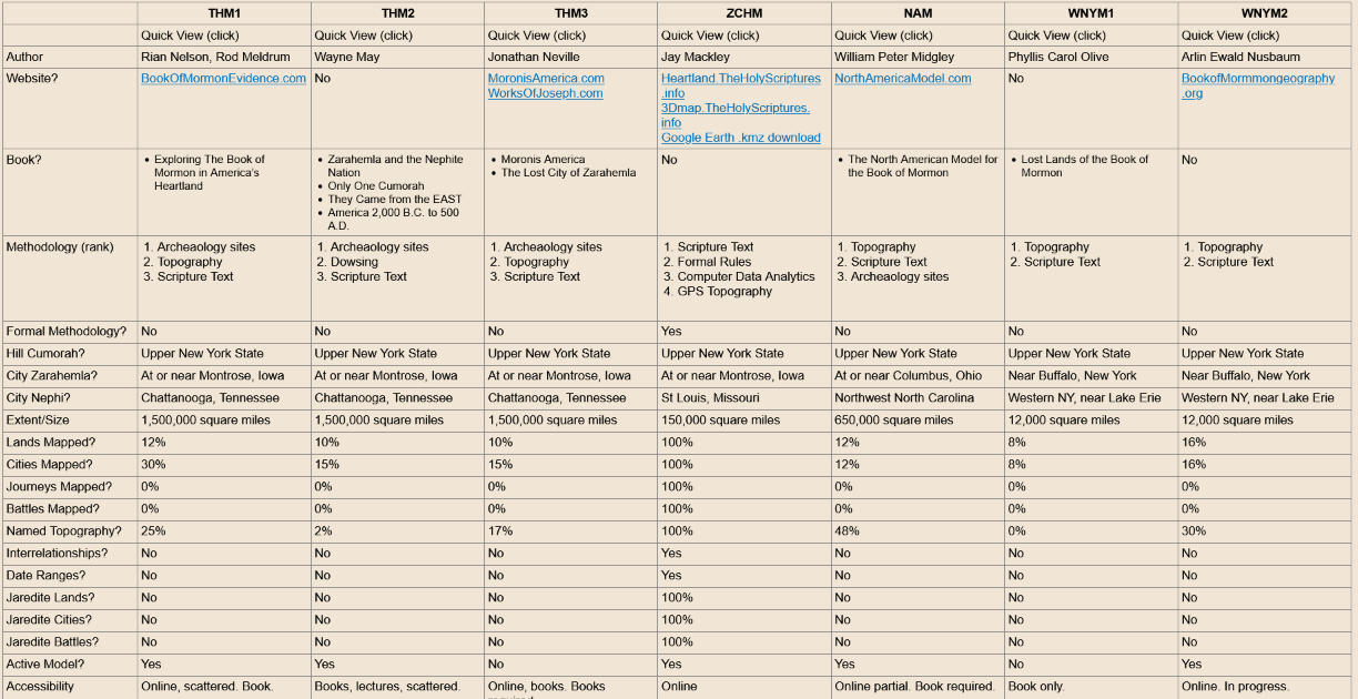
Unfortunately, The Holy Book of Mormon is NOT mentioned in the Mission Statement of the Heartland Research Group:
Mission Statement
The Heartland Research Group researches archaeological evidence of the ancient civilizations of America.
Heartland Research Group activities include:
Field Research
Uses archeological techniques and scanning technologies to reveal the remains of ancient civilizations.
Ancient Artifacts
Encourages and facilitate study of ancient North American artifacts, including tablets, tools, weapons, metal works, and other items.
Geography
Research and develop maps, using scanning technologies and other means, to identify the locations and activities of ancient civilizations.
Linguistics
Analyze and translate ancient writings found in North America, especially those relating to other civilizations world wide.
Preservation and Display
Collect, restore, preserve, catalog and exhibit ancient artifacts and replicas, and make them readily available to researchers and viewable to the public.
Archaeology, Geology, and History
Study and research into all aspects archaeology, geology, and history that shed light on ancient North American peoples and cultures.
Promotion and Support
Raise awareness of our activities. Work directly with and support individuals and groups in activities that share our same goals.
The Heartland Research Group welcomes researchers and interested parties of all backgrounds to share their analysis and findings of ancient American heartland civilizations. (theheartlandresearchgroup.org/book-of-mormon-geography/)
Not Christ-Centric
Unfortunately, #2, Christ is not the center of their “Heartland” models; Joseph Smith is. All of this extends from Rodney Meldrum’s attempts to legitimize his model by drawing parallels to Church Historical sites, with Wayne May pushing the narrative that the ancient temple of Zarahemla is across the Mississippi River from Nauvoo (and its temple).
But Zarahemla, its city and temple, was destroyed at Christ’s coming and then again towards the end because of wickedness, and Jesus never visited it. Where did Our Lord visit? The temple in Bountiful. Where was the Bountiful Temple located? Near the Narrow Neck of land. So why are they not feverishly excavating their alleged City of Bountiful sites for that temple?
Should all Book of Mormon Geography models be Christ-centered? Yes. Why? Because the sacred record is about Him, and it’s where Our Lord will return before going to Jerusalem. All Book of Mormon land prophecies were fulfilled during Colonial America, and any model with lands outside Colonial America was disqualified.
What’s wrong with the Premise of the Heartland Research Group should be evident to the most ardent students of Book of Mormon Geography:
THE PREMISE of the Heartland Research Group is that the lands and cities mentioned in the Book of Mormon are located in the HEARTLAND of North America, that the hill Cumorah is in upper New York state and that ZARAHEMLA is located across the river from NAUVOO. We believe this is consistent with the scriptures and the physical discoveries made thus far in the heartland. Beyond Cumorah and Zarahemla, the Heartland Research Group has NO OTHER CONSENSUS (theheartlandresearchgroup.org/book-of-mormon-geography/)
Omer, a Jaredite, traveled past Cumorah to Ablom. The Jaredites only lived in the Land Northward; therefore, Jaredite lands are near Palmyra. Four seas surrounded Jaredite lands. There’s only one body of water north of Palmyra—Lake Ontario. Therefore, Lake Ontario IS the Sea North, and the other three seas can easily be ascertained, as we have done.
Faulty Model Comparisons
Just as their Mission Statement is devoid of references to The Holy Book of Mormon, and Christ is not at the center of their model, there’s a void in the recognition of anything spiritual in the criteria used in this Comparison Chart. All land prophecies were fulfilled during Colonial America and within its boundaries; no wonder Heartlanders and Mesotheorists ignored them.
This model comes to us from Jay Mackley (a Computer Scientist, BYU), who has naturally applied his skill set to proving Book of Mormon Geography. His “Logical Model” is unique and what one would expect from someone with his background. He assures readers he had no physical area in mind (he hails from Fort Madison, Iowa) before creating the Logical Model:
“The ‘Methodology’ is the systematic application of procedures used to create the components of the Logical Model and the Physical Model. The methodology outlined below was used to construct a Logical Model of Book of Mormon geography AND the Zarahemla Centric Heartland Model map of the Book of Mormon. Yes, the Logical Model was actually created in it’s entirety first, then the Physical Model was afterwards created.” (3.2 The Methodology, https://zchm.theholyscriptures.info/)
He goes on to say:
“After the initial construction of a Physical Model, subsequent iterative improvements always start with the Logical Model and then ‘trickle down’ to the Physical Model to keep it compatible.”
This is most unfortunate, for the “eyes on the ground” view should have some bearing on how the data is interpreted. Also, it would have been helpful for Mackley to construct an Internal (abstract) Map first (as suggested by Sorenson et al.) as proof that his data is not experiencing a “reverse trickle” from the physical area he settled on.
While his approach is novel, it’s not the first to tabulate Book of Mormon Geography data and “map it” using a relational database with many charts:
Where did Helaman’s two thousand stripling warriors battle the Lamanites? Where in the Americas did the Savior appear after his resurrection? Scriptural history becomes more alive and real to the reader as professional archaeologist F. Richard Hauck identifies specific locations in southern Mexico and Guatemala as possible Book of Mormon sites. Deciphering the Geography of the Book of Mormon relates present-day towns and cities to Book of Mormon locations, including Zarahemla, Nephi, Bountiful, Manti, Gideon, and Ammonihah. More that fifty maps and charts are included.
Dr. Hauck, a professional archaeologist, first constructed a geographical model based only on descriptions specifically stated in the Book of Mormon. Only after he had reconstructed the settlement systems into an ABSTRACT, GEOMETRIC MODELdid he attempt to identify Book of Mormon settings as actual locations in the Americas. The model was then taken into the field, where ancient ruins were located that correlate with ancient settlements and fortifications described in the Book of Mormon.
Deciphering the Geography of the Book of Mormon is a study guide for those wanting to better understand the geography and history of the Book of Mormon. It will also be of great interest to those desiring a rigorous scientific approach to the settlement and route networks described in this important book of scripture. (Dr. F. Richard Hauck – “Deciphering the geography of the Book of Mormon : settlements and routes in ancient America” Deseret Book, 1988)
As can be seen, Mackley was not the first person to claim a data-driven approach before choosing a physical location. How objective can a person be if they are: a. An archaeologist specializing in Mesoamerica (Hauck), b. Do you live in the area suggested (Mackley)?
1.5 days or 50 miles from the Sea West to the Sea East
Less than a day (less than 30 miles)Bountiful to Manti
Less than a day (less than 30 miles) from the City Zarahemla to the Sea East
Travel by Water
Mackley has a second novel approach. He postulates travels by water where no such statements are made.
The ‘narrow neck of land’ is part of the land of Bountiful and is included in the geographical description of the most important, strategical area of Nephite territory. Upper Michigan and the St Marys river border, between Michigan and Ontario, is by far the most extensively described area in all of the Book of Mormon. The fact that Upper Michigan fits so well with the Book of Morman narrative is a major factor in favor on the Zarahemla Centric Heartland Model map.
This area was considered critically important for military reasons as well as for controlling trade and migration northward.
The distance from Lake Superior to Lake Michigan/Huron is 63.2 miles. According to Section 3.2 Rules of Interpretation Rules of Application, a day and a half journey WITH THE CURRENT should be 72 miles and a day and a half journey AGAINST THE CURRENT should be 48 miles for an average of 60 miles, so that is a pretty good match to the actual distance.” (Reign of the Judges [91 BC to 30 AD] : NeckOfLand)
Mackley has fallen into the same mental trap as Rodney Meldrum in assuming boats were used to carry lumber or people in the Land Southward, but no single reference to support this claim. The only references are for the Land Northward.
Sea South
Mackley’s model was not immune to the H38 Virus, and he has not a single piece of land directly surrounded by four bodies of water, as Helaman 3:8 says:
8 And it came to pass that they did multiply and spread and did go forth from the land southward to the LAND NORTHWARD and did spread insomuch that they began to cover the face of the whole earth, from the SEA SOUTH to the SEA NORTH, from the SEA WEST to the SEA EAST. (Helaman 3)
This is not a general expression for “everything.” Consider the following:
20 And thus it did come to pass that the people of Nephi began to prosper again in the land, and began to build up their waste places, and began to multiply and spread, even until they did cover the WHOLE FACE OF THE LAND, both on the northward and on the southward, from the SEA WEST to the SEA EAST. (Helaman 11)
Just because a model does not have land bordered directly by four bodies of water does not give the researcher the right to change, ignore, misinterpret, or claim that the text is a metaphor (see H38 Virus for further details). The H38 Virus test is a quick way to learn whether a modeler has been faithful to the text.
This is Mackley’s Sea South entry:
Reign of the Judges [91 BC to 30 AD] : Sea South
The sea south is GLOBALLY ALL-INCLUSIVE IN ITS EXTENT, when describing the Book of Mormon lands.
Modern Feature Location: Gulf of Mexico. Geolocation: N 28° 25′ 35.3″, W 90° 47′ 35.1″
It’s an excellent example of how one’s understanding or bias affects even purely “data-driven” approaches. To overlook the fact that the Sea South was only south of the Land Northward is a major flaw in one’s understanding of the text. And, the Land Northward was never known as a “Lamanite” land. See Sea South and Sea North for additional scriptures on those bodies of water.
River Head
The following statement by Mackley may land him in the hot seat with Heartlanders because at the core of Rodney Meldrum’s model, “head” must mean “confluence”; otherwise, his model won’t work (see Rodney Meldrum).
Note that to attack Zarahemla the Lamanites would ‘march down’ but to attack Nephihah they would ‘cross the head of Sidon’. IT IS CLEAR from 1 Nephi 8:14 (‘And I looked to behold from whence it came; and I saw the head thereof a little way off’) THAT THE HEAD OF A RIVER IS THE SOURCE WHERE IT ORIGINATES.
One may think of the head as a very small stream — as it was when Louis and Clark were looking for the head of the Missouri continental divide. If this was also true in the case with the Sidon, then the head would be somewhat nebulous and crossing it would not be a reference point of significance. However, the Book of Mormon makes several matter-of-fact references to the head of the Sidon indicating it was well known and well defined, which would indeed be the case when THE HEAD IS ST CROIX LAKE. (4.5.3 War of Amalickiah – Stripling Soldiers)
While there is considerable enthusiasm for Zarahemla being found where Wayne May believes it was located to coincide with Church history, his theory will collapse because that’s not where Zarahemla was (which is not to say that objects from Book of Mormon time won’t be found; they just won’t be Nephite, they will be Lamanite “by birth,” i.e., the pre-existing peoples who were already there; see Others).
Prophetic Fulfillment
The Spiritual Geography, as I have termed it (where land prophecies were fulfilled; see Prophecies), excludes lands beyond Colonial America and certainly not in Canada (except for Hagoth).
Jaredite Lands
Jay Mackley rightly acknowledged that most modelers don’t know where to place Jaredite lands. And yet, those who accept the “one Cumorah” ideology are very aware of the references to Palmyra and the Jaredite Omer, who it says walked through that area:
3 And the Lord warned Omer in a dream that he should depart out of the land; wherefore Omer departed out of the land with his family, and traveled many days, and came over and passed by the hill of Shim, and came over by the place where the Nephites were destroyed [Palmyra, NY], and from thence eastward, and came to a place which was called Ablom, by the seashore, and there he pitched his tent, and also his sons and his daughters, and all his household, save it were Jared and his family. (Ether 9)
This means that Jaredite lands, which were surrounded by four seas and referred to as the Land Northward, are located in western New York. The largest sea on the north – Lake Ontario is the Sea North (and Ripliancum); from there, the other seas can easily be ascertained (see Omer).
Additionally, all ancient Book of Mormon temple locations have been identified and are being protected (see Temples). The Bountiful temple is highly important, for that is where Our Lord will first come when He returns. See America’s Mount Zion for details: