The expression “truth is stranger than fiction” applies to geography models—perhaps more than anything else—due to how land changes over time (2000+ years for Book of Mormon lands). These are real maps because they are real geography. For our scriptural support, go here: Zarahemla.
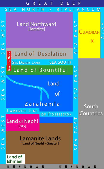
The Land of Zarahemla encompasses the area south of the Land of Bountiful and north of the Lamanite Line of Possession, which is bordered by the Seas East and West. Much of this land was altered at the coming of Jesus; many cities were destroyed. Whatever cities were or could be rebuilt were again destroyed in the lead-up to the final Nephite war of extinction. The cities of Bountiful, Zarahemla, and Manti are firm, as are the East Sea, West Sea, and Lamanite Line of Possession.
[keyboard instructions: double click to zoom; use arrow keys to move the map or click and drag]
In the valley east of Hill Amnihu; also called Land of Gideon. Alma first stop and preached here after leaving his home in the city of Zarahemla. From here he traveled south to the land and city of Manti.
Location is approximate.
On the other side of the River Sidon just east of Zarahemla.
The Sea South emptied on its north via four spillways: Lockport, Gasport, Medina, and Holley.
The Sea South emptied on its north via four spillways: Lockport, Gasport, Medina, and Holley.
The Sea South emptied on its north via four spillways: Lockport, Gasport, Medina, and Holley.
The Sea South emptied on its north via four spillways: Lockport, Gasport, Medina, and Holley.
Remnants of the western edge of Ancient Lake Tonawanda at its largest size is Beach Ridge Rd. Evidence of the western edge in its smaller size is Bear Ridge Rd.
This inlet that splits into Tonawanda and Ellicott Creeks was one body of water called Sea That Divides the Land, which fed the larger inland sea called Ancient Lake Tonawanda/Sea South. from water from the Sea West now called Lake Erie/Niagara River.
Google Map Wordpress
Marker Form will be displayed only for logged in users.
Log In
Internal Map