Mulek’s ship docked at a naturally occurring pier called “Black Rock Pier” in Black Rock, western New York, just north of Buffalo:
Blackrock received its name and its reason for existence by virtue of a LARGE WEDGE OF BLACK LIMESTONE FORMATION THAT PROJECTED AT A NORTHWESTERLY ANGLE INTO THE NIAGARA RIVER near the point where School Street and Niagara Street intersect. Its FLAT SURFACE WAS 200 FEET WIDE at its northern end and ROSE FOUR OR FIVE FEET ABOVE THE NORMAL WATER LEVEL OF THE RIVER – Kis-tan-goi, as the Senecas called it, thus formed A NATURAL PIER (Landmark Society, n.d.). THE ROCK FORMED A PERFECT NATURAL LANDING PLACE AND WAS USED AS EARLY AS THE TIME OF THE AMERICAN REVOLUTION AS A FERRY POINT (General Motors Tonawanda Engine Plant Expansion, Stage 1 Archaeological Investigation, OPRHP, No. 00 PR 116, August 4, 2000, p. 3-42).
Peter B. Porter, one of the earliest settlers of the Black Rock area and a partner of the portage company (Porter, Barton and Company), believed that their village would become the center of Lake Erie trade, by virtue of the NATURAL HARBOR and because the harbor at Buffalo was often impassable due to sand bars (Severance 1902) (Ibid, p. 3-44).
Buffalo also improved its harbor, however, and once the choice of Buffalo was made as the western terminus of the Canal, Buffalo quickly eclipsed Black Rock as a lake port. Symbolic of this, the rock formation which gave Black Rock its name was destroyed in conjunction with construction of the Erie Canal to Buffalo (Severance 1902; Bingham 1931) (Ibid, p. 3-45).

Commentary
What Was the ‘Black Rock’ in Black Rock?
[The illustrations and text below are reprinted from “The Picture Book of Earlier Buffalo,” Severance, Frank H., ed. Buffalo Historical Society, Vol. 16, 1912, in a chapter entitled “Early Black Rock Facts.”]
Herewith is published for the first time a map of a section of the Niagara river as it was before the War of 1812 showing the site of the old ferry at the foot of the Black Rock and many other data of value. Our engraving is from a sketch made from the original drawing owned by the Buffalo Historical Society. The original bears this inscription:
“Compiled and drawn from recollection and actual surveys and information furnished by Captain James Sloan, Lester Brace, Col. William A. Bird and E.D. Efner, Esq.,” by Henry Lovejoy, Surveyor, who was familiar with the location from 1810 to the present time”
The date of Mr. Lovejoy’s drawing was December, 1863. The information relative to the Canada side was furnished to Mr. Lovejoy by Alexander Douglas of Fort Erie. On the original drawing are written descriptive notes. These on the engraving are indicated by numerals, the explanation of which follows:
1. [Far left, just below the middle of the drawing] Starting at the left of the map on the American side is shown the main traveled road from Black Rock ferry to Buffalo before and during the War of 1812. It also ran to the eddy under Bird Island, where vessels discharged and received most of their freight. “The road was up and along the shore of the river and the beach of the lake to the mouth of the Big Buffalo creek; up the bank of the Big Buffalo creek to the mouth of the Little Buffalo creek and up the bank of the Little Buffalo creek to its angle, now [1863] foot of Pearl street; thence direct to the Terrace at the junction of Main and Exchange streets.”
2. [ To the right of #1] Sand ridge behind which some men took shelter from the enemy’s guns. They were engaged the day before Buffalo was burned in towing vessels belonging to Joshua Lovejoy up the rapids, when the enemy opened fire upon them. They were obliged to swing the vessel ashore and retreated behind the sand ridge, which was full protection. The vessel had several shot through her, but was not disabled. Her guns were soon brought to bear on the enemy and they were driven off. Dr. Trowbridge served one of our guns.
3. [to the left of #4] Site of Water-works, 1863.
4. Lester Brace’s garden.
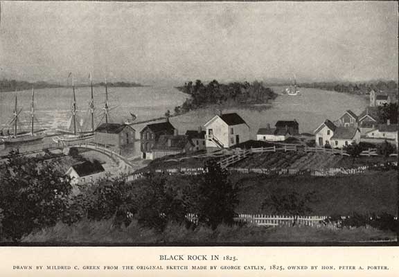
The Black Rock plainly shown on the diagram was a ledge or outcropping of the native country rock [Ed. Note: Onondaga limestone], narrowing at its southern end until it disappeared in the bank. At the northerly end it presented a broad line of cleavage forming a natural wharf, with a landing for boats somewhat protected from the force of the current. This rock was blown up and destroyed in 1825 when the [Erie] canal was built.
Three buildings stood on the rock, as follows:
5. A log house occupied by Orange Dean. Before the war he was employed at the old ferry. During the war it was occupied by E. D. Efner and from it he furnished clothing for Swift’s regiment.
6. Clark’s grocery and boarding-house.
7. Store built by Porter & Barton, and kept as a tavern during the war until Buffalo was burned, by Orange Dean. It had several shot through it from the enemy’s guns. One, while Dr. Trowbridge was dressing the wounds of some of the men who had been engaged in taking the brigs Adams and Caledonia.
8. Lester Brace’s barn
9. A building nearly in line of Fort street of later days, was a log house occupied before the war by Frederick Miller as the ferry-house and tavern. Occupied during the war by Holden Allen as a tavern until Buffalo was burned. Rebuilt after the war on the same location by Lester Brace and occupied by him as a tavern and the ferry-house for a long time.
Before leaving the Black Rock it may be noted that the ferry landing was in the protected angle at the north end of the ledge. The old ferry-boat was about 32 feet long by 8 feet wide, with two sweeps and a steering oar. The ferry charges were: per man, 2 shillings; man and horse, 4 shillings; one horse wagon, 10 shillings; two horse wagon, 12 shillings.
The current at this point in the middle of the stream being about 6 to 7 miles an hour, the old route in crossing was to swing into the current and float down stream with it, gradually making the Canada shore at about the point near the figure 31 on our map. From that landing the boat made its way up stream close in shore until opposite the Black Rock, when it again swung out and was carried down stream to about the present Ferry street, whence it was rowed up to the rock. This route is shown by the light dotted line on the map (Chuck LaChiusa, https://buffaloah.com/h/br/sev/index.html).
In the following illustration of Black Rock, a ship can be seen docked along the outer-edge of the pier next to a building (store, #7), and before the building a bridge that crosses the water to a cabin (#9), and next to it a large white barn (#8) with gardens. The land was slightly raised and flat bordering the river looking north. This area was part of the Narrow Neck of Land.
The Historical Marker Database
An excellent expose on the history of Black Rock with hi-res pictures. A sampling:
The Black Rock ‘Kis-tan-goi’ The “Black Rock” was a large flat shelf of limestone and chert that extended into the Niagara River forming a natural harbor and pier. The rock was located near the foot of present day School Street just north of the Peace Bridge. The Native Americans had been coming to the rock for centuries to obtain the raw material necessary for the manufacture of weapons and tools. This black chert, of flint, was found on the BLUFF ABOVE THE BLACK ROCK and was the only local source of this valuable material. Early settlers near the rock reported the ground was heavily littered with stone chips and flakes, a result of generations of Native Americans manufacturing stone implements at the site. Arrowheads and tools made of Black Rock chert have been found throughout the region and as far away as Ohio and Pennsylvania indicating the significance of Black Rock chert to the earliest inhabitants of the region.
Plus an excellent timeline from the same source:
•1650 The Seneca’s called the black rock “Kis-Ta-Goi”
•1679 The “Griffon, first vessel to sail the Great Lakes was outfitted at Squaw Island [renamed Unity Island].
•Jasper Parrish is given title to the land at Black Rock by the Senecas.
•1800 Scajaquada Creek is named for “Conjockety, a Native American that lived on the creek.
•1804 Military Road built to connect Black Rock and Fort Niagara.
•1805 First land sales in Black Rock.
•1811 Four farm lots surveyed into a village plot called Lower Black Rock.
•1812 War of 1812 begins.
•1813 British troops burn Black Rock and Buffalo.
•1813 Commodore Perry establishes shipyard at Scajaquada Creek.
•1814 Battle of Scajaquada Bridge; Black Rock defended.
•1818 The “Walk in By Anton Schwarzmueller, April 10, 2016
•1825 Erie Canal completed, lock and dam built at Black Rock.
•1827 Jubilee Springs incorporated to supply fresh water to Black Rock.
•1830 Porter Square and Market Square donated by Peter B. Porter.
•1830 Howell House and store and Smith House and Tavern constructed.
•1836 Buffalo and Niagara Falls Railroad reaches Black Rock.
•1839 Niagara Street extended through Black Rock, old Niagara Street renamed Dearborn Street.
•1840 Newcomb’s Canal Store at Amherst Street operates 24 hours a day, 7 days a week.
•1850 Black Rock is known as a “hotbed” of abolitionist activity.
•1854 City of Buffalo annexes the Village of Black Rock.
Special thanks to Anton Schwarzmueller for that great source of information and recent pictures!!
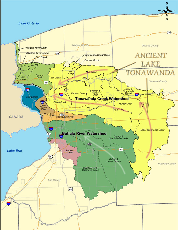
Watershed Map
The watershed map for this area shows this unique, bordering “neck” of land in brown: