This page is about the Book of Mormon geography by Wayne May, the founder of Ancient American magazine and author of This Land book series. Here are some of the deficiencies in his model:
- Wayne May places the Narrow Pass and Land Northward in Canada, which is ruled under a monarchy, but the Book of Mormon states: there shall be no kings upon the land (2 Nephi 2:11)
- He has no sea directly west of Zarahemla
- No sea directly east of Zarahemla
Stated travel times make it clear Book of Mormon lands were small like Bible lands, not huge like the United States or India:
- 1.5 days or 50 miles from the Sea West to the Sea East
- Less than a day (less than 30 miles) Bountiful to Manti
- Less than a day (less than 30 miles) from the City Zarahemla to the Sea East
- See Line Defined for details
The Narrow Pass in his model is not “narrow” from eye level if you’re walking through it. Book of Mormon writers, Mormon, Moroni, etc., mention the terrain as they saw it from eye level and traversed it in daily life, not as we do in modern times from a satellite map of the entire continent.

(Land Southward to Land Northward, Narrow Pass Map, Wayne May, “Book of Mormon Geography” presentation, Ancient American History Conference, SLC, April 1, 2011)
The following map (and measurements in miles) show just how not-narrow Wayne May’s purported Narrow Pass is:
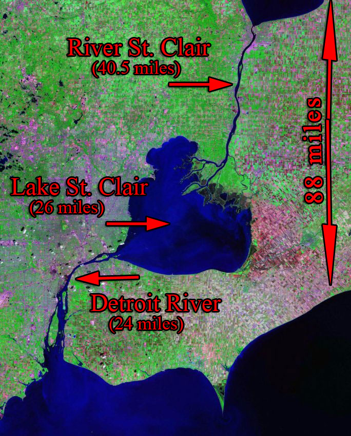
Detroit River is 24 miles long, the St. Clair River is 40.5 miles long, and Lake St. Clair is 26 miles long for a total width of 88 MILES WIDE. What warrants the width of that area to be called “narrow” is a mystery; MORMON DID NOT HAVE SATELLITE MAPS.
Wayne May’s Narrow Pass is NOT EVEN REACHABLE due to the treacherous Detroit and St. Clair Rivers, which carry freight liners:
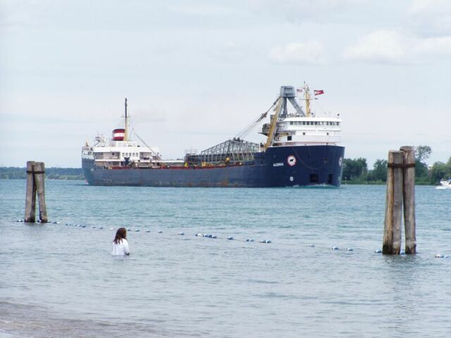
Freighter on St. Clair River
Nothing stopped animals and people from passing back and forth through the Narrow Pass except poisonous serpents:
33 And it came to pass that the Lord did cause the serpents that they should pursue them no more, but that they should hedge up the way that the people could not pass, that whoso should attempt to pass might fall by the poisonous serpents. (Ether 9)
Even if somehow the people and animals were passing through those treacherous waters and Wayne May wanted to claim the land further north was his “narrow” pass at its narrowest point, we are still talking about a width of 14 miles, which is equivalent to the distance between Sandy and Park City, or between Salt Lake City and Saltair. No one would even call the shorter distance between the Salt Lake Airport and downtown Salt Lake City as “narrow,” which is 4 miles wide. Mormon used the smallest unit of expression in the Book of Mormon to identify or express that Pass—narrow/*******
32 there being a SMALL NECK of land between the land northward (Alma 22)
5 by the NARROW NECK which led into the land northward (Alma 63)
34 by the NARROW PASS which led by the sea into the land northward (Alma 50)
The other use of the word narrow is in reference to a “narrow” path along some railing and provides clues for the mysterious Narrow Pass:
19 And I beheld a rod of iron, and it extended ALONG THE BANK OF THE RIVER and led to the tree by which I stood.
20 And I also beheld a strait and NARROW PATH which came along BY THE ROD OF IRON even to the tree by which I stood; and it also led by the HEAD OF THE FOUNTAIN (1 Nephi 8)
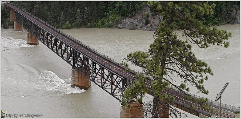
This is the image we should have as we ponder the Narrow Pass, not a 14-mile wide by 250-mile long flat piece of land under a monarch’s rule. A pedestrian bridge over the dangerous currents of the St. Clair River:
May’s contradictory map:
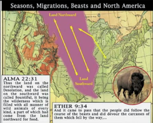
Land Southward to Land Northward Map – Animal Migrations (Wayne May, “Book of Mormon Geography” presentation, Ancient American History Conference, SLC, April 1, 2011)
Wayne May says the Land of Nephi (Tennessee) was a higher elevation than the Land of Zarahemla (Illinois):
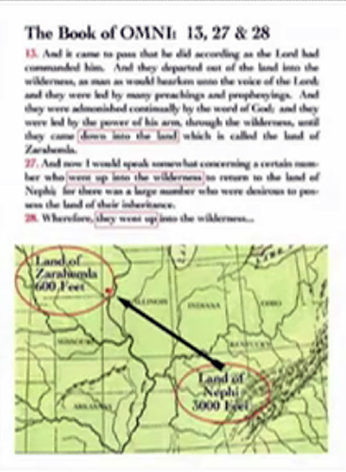
Higher to Lower Elevation Map (Wayne May, “Book of Mormon Geography” presentation, Ancient American History Conference, SLC, April 1, 2011)
Rivers flow from higher elevations to lower elevations. Wayne May’s River Sidon (Mississippi River) flows the wrong way.
May says the Hopewell were the Nephites
No. The Nephite culture was a sub-culture of a larger pre-existing Lamanite culture group. The Hopewell were Lamanites by birth (for more information on the definitions of “Lamanite,” go to: http://www.bookofmormongeography.org/basics/introduction/lamanites/ ).
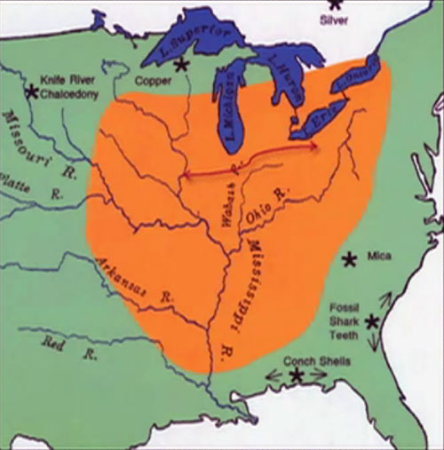
Hopewell Sphere of Influence Map (Wayne May, “Book of Mormon Geography” presentation, Ancient American History Conference, SLC, April 1, 2011)
Hopewell Migration West to East (See #8):
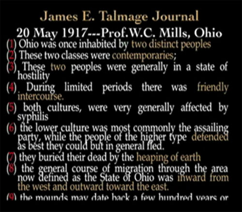
Hopewell Migration Through Ohio – West to East – Map (Wayne May, “Book of Mormon Geography” presentation, Ancient American History Conference, SLC, April 1, 2011)
Unfortunately, Book of Mormon migrations were NORTH, NOT EAST:
- North from Lehi’s landing point (Land of Ishmael) to Nephi’s city
- North from Nephi’s city to the City of Zarahemla
- North from Zarahemla to Bountiful
- North from Bountiful to Desolation
- North from Land Southward to Land Northward
The only people who migrated east were Lamanites.
OMISSIONS
Wayne May has ignored the following points:
- A sea directly West of Zarahemla
- A sea directly East of Zarahemla
- Nephite cities along the Sea East
- Nephite cities along the Sea West
- The Jaredite Land Northward, directly surrounded by FOUR SEAS
May has yet to produce an Internal Map, as Dr. Sorenson and others suggested, which is common sense. He, like Meldrum, has unfortunately put the cart before the horse.