The Prophecies
Something else that is or should be shown to have occurred is a massive change in the land. The following verse is what was prophesied, followed by the verse of what happened:
12 And all these things must surely come saith the prophet Zenos and the rocks of the earth must rend; (1 Nephi 19:12)
21 Yea at the time that he shall yield up the ghost there shall be thunderings and lightnings for the space of many hours and the earth shall shake and tremble and the rocks which are upon the face of this earth which are both above the earth and beneath which ye know at this time are solid or the more part of it is one solid mass shall be broken up
22 Yea they shall be rent in twain and shall ever after be found in seams and in cracks and in broken fragments upon the face of the whole earth yea both above the earth and beneath. (Helaman 14:21-22)11 And there was a great and terrible destruction in the land southward.
12 But behold, there was a more great and terrible destruction in the land northward; for behold, the whole face of the land was changed, because of the tempest and the whirlwinds, and the thunderings and the lightnings, and the exceedingly great quaking of the whole earth;
13 And the highways were broken up, and the level roads were spoiled, and many smooth places became rough.
18 And behold the rocks were rent in twain yea they were broken up upon the face of the whole earth insomuch that they were found in broken fragments and in seams and in cracks upon all the face of the land. (3 Nephi 8:11-13, 18)
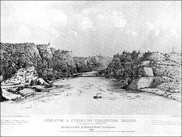
Proof of this change can easily be seen today just below the Niagara Country Club. Please note the distance the land has receded on the following map from the Niagara Country Club to current day Niagara Falls:

The next image shows how much the land was pushed up:

This image was shot from the Canadian side looking under the Rainbow Bridge northward toward Lake Ontario/Sea North.

The Niagara River was diverted and damned for repairs in 1969. This view shows clearly how the land was lifted fulfilling the prophecy that:
21 Yea at the time that he shall yield up the ghost there shall be thunderings and lightnings for the space of many hours and the earth shall shake and tremble and the rocks which are upon the face of this earth which are both above the earth and beneath which ye know at this time are solid or the more part of it is one solid mass shall be broken up
22 Yea they shall be rent in twain and shall ever after be found in seams and in cracks and in broken fragments upon the face of the whole earth yea both above the earth and beneath. (Helaman 14:21-22)
Rare 1969 movie footage when the Niagara River ran dry. The land displacement is clear.
More movie footage when the Niagara River ran dry, showing land displacement.
The displacement you see fulfills the prophecies cited above.
This image is looking from the opposite direction. Notice the forest bordering the river’s edge in both pictures. That is virgin forest from Book of Mormon time.
The falls were first studied by one of modern geologies founding fathers, Charles Lyle. Lyle, who pioneered the early understanding of earth secrets was intrigued by the concept of geological time. Lyle (1840’s) was using the principle that things that we see are going on today can be used as examples for what went on in the past (Dr. Marcus Bursik, University of Buffalo).
Lyle believed the world wasn’t shaped in a few days or even years. But by slow change, over millions and billions of years. This directly contradicted the much shorter time Biblical scholars said the world had been in existence. Lyle realized that dramatic geological change was going on in front of his eyes at Niagara Falls. If he could measure it, he might be able to calculate the fall’s age. Lyle’s technique was brilliantly simple. He noticed below the falls, was a great gorge locals said was steadily increasing in length, as the water wore away the ledge of the falls. The falls they said were slowly moving upstream.
To discover the age of the falls, all Lyle needed was some simple math.
“He realized that the falls had started at Niagara Escarpment, which is about 35,000 feet from here [the current falls]. So if the falls receding at one foot per year, and receded 35,000 feet that would give an age for their present position of 35,000 years” (Dr. Marcus Bursik, University of Buffalo).
Lyle’s calculation was based on simple measurements, but wrong guesswork. He thought the falls were receding by one foot a year, but today we have much better records to go on.
“This plaque commemorates Table Rock which is where the falls were at the beginning of the 19th century. Since that time they’ve receded about 600 feet” (Dr. Marcus Bursik, University of Buffalo).
So in the last 200 years, the falls have steadily retreated at a rate of not one foot, but an astonishing three feet a year. So instead of Lyle’s calculation of 35,000 years old, the Niagara Falls were a third of that figure. Just 12,000 years old. A mere blink of an eye in earth’s 4.5 billion year history (“How the Earth Was Made – Great Lakes” History Channel, 3/24/2009).
That is an oversimplification, particularly when modern restricted flow rates (50%-75% prevented), seasonal changes, sudden ledge collapses (as listed below), and the initial loss when the land changed, are not factored in.
- 1818 – Huge rockfall in the American Fall produced an earthquake
- 1823 – Large piece of Table Rock fell
- 1828 – Large section of Horseshoe Fall fell producing an earthquake
- 1846 – Large section of Table Rock collapsed
- 1850 – Large section of Table Rock collapsed
- 1852 – Large piece of Horseshoe Fall fell
- 1882 – Section of the Horseshoe fell
- 1889 – Section of the Horseshoe fell
- 1905 – Section of the Horseshoe Fall fell
- 1931 – 280 foot section collapsed from the American Fall
- 1934 – Section of the Horseshoe Fall fell
- 1936 – Section of the Horseshoe Fall fell
- 1937 – Section of the Horseshoe Fall fell
- 1954 – Largest rockfall at the American Fall
- 1954 – A 190 foot by 40 foot section at the American Fall feel
- 1963 – 1000 tons of material fell into the gorge at Goat Island
- 1967 – 100 tons dislodged from the dry wall crest at Prospect Point
- 1974 – 7 tons fell from cliff above Maid of the Mist building
Q. Was the gorge made during the ice age?
No. The gorge has been made by the Horseshoe Fall since the end of the ice age.
Q. What will happen to the falls in the future?
This is a very difficult question to answer. Since the flow of the upper river is controlled by the power authorities, and much remedial work has been done the past few decades to reinforce the falls and their immediate surroundings, the falls will probably change very little for a long time to come. Nature had intended to dry up the American Fall and Bridal Veil Fall, but water is forced into their channels using the water control dam upriver. The Horshoe Fall would have continued cutting out a gorge for quite some time, rising another 60 feet (18.3 meters) in height, but it has slowed down, and some scientists think it will stay in one place, like the American Fall and Bridal Veil Fall. Only time will tell what effects human efforts will have on the great cataracts.
[Source: Paul Gromosiak, Niagara Falls Q & A, 1989]
Of course, a more practical framework is one that allows for sudden land changes rather than attributing everything to retreating glaciers:
“In the 1920s, however, when borings were made for a railroad bridge, it was found that the middle part of Whirlpool Rapids Gorge of Niagara Falls contained a thick deposit of glacial boulder clay, indicating that it had been excavated once, had been filled with drift, and then partly re-excavated by the falls in post-glacial times” (Immanuel Velikovsky, Earth in Upheaval, (1955) Paradigma 2009 edition, p. 151).
“R. F. Flint of Yale writes: ‘We are obliged to fall back on the Upper Great Gorge, the upper most segment of the whole gorge, which appears to be genuinely post-glacial” (p. 151).
“If due allowance is made for this last factor, the age of the Upper Great Gorge of Niagara Falls would be between 2500-3500 years (p. 151-152).
“Careful investigation by W. A. Johnston of the Niagara River bed disclosed that the present channel was cut by the falls less than 4,000 years ago” (p. 184).
(see also W. A. Johnston, “The Age of the Upper Great Gorge of Niagara River,” Transactions of the Royal Society of Canada, Ser.3, Vol.22, Sec.4, p. 151; F. B. Taylor, “New Facts on the Niagara Gorge,” Michigan Academy of Sciences, XII, 1929)
GREAT EARTHQUAKE
Researchers find evidence of a GREAT EARTHQUAKE in the Lake Erie – Lake Ontario area which is causing them to rethink their models:
Researchers warn Southern Ontario may face earthquakes WATERLOO, Ont. —
If a controversial theory put forth by a team of researchers studying seismic activity in Lake Ontario proves correct, Southern Ontario is more earthquake-prone than was previously believed.
‘It’s a fairly highly populated area, so it introduces an element of risk which didn’t exist before in the minds of people,’ says Prof. Richard Thomas, head of the research team and director of the Waterloo Center for Groundwater Research based at the University of Waterloo.
Scans of the bottom of Lake Ontario conducted during searches for downed aircraft revealed three previously undocumented features. Using that data and studies of their own, the research team identified the features as the result of tectonic activity due to a fault line.
The three features, known as pop-ups, plumose structures and dark linear patterns, are located in western Lake Ontario. A pop-up is a ridge with a crack at the top, formed when the bedrock fractures because of compressional forces in the crust. A plumose structure is several kilometres long and looks like a feather etched into the lake bottom. The dark linear patterns are believed to be due to natural gas coming up through the rocks into the bottom sediments.
Interestingly enough, says Thomas, the features all occur on the same line going through Burlington to Toronto. ‘In 1987 and 1988, there were two earthquakes recorded right on that line, which were about magnitude 3.5 (on the Richter scale). So there is earthquake evidence to suggest that the interpretation of these features is correct.’
‘This indicates a major fault structure occurring in that part of the lake. . . . What it indicates is that there is a greater likelihood of a significant earthquake taking place than was originally believed.’
Earthquakes occurring in the Great Lakes region were thought to be in response to crustal rebound caused by the removal of ice from the last ice age. ‘Now, crustal rebound is taking place, but if you look at the pattern, it’s not random,’ Thomas says. ‘The pattern would suggest that it’s following a quite distinct orientation.’
Additional work has revealed faulting in the south-eastern part of Lake Ontario. The scientists are coming to believe that Lake Ontario and possibly Lake Erie lie on an extension of the well-known St. Lawrence fault system.
The growing realization that fault lines could occur in the middle of a continent has led to a new science called intra-plate tectonics. ‘These are (earthquake) areas occurring in the middle of plates. The traditional belief was that all activity occurred on (continental) plate margins, where they collide or are in motion. They (mid- continental faults) are basically resulting from the various pressures induced on the plate because they’re in motion, and these are lines of weakness which are currently being re-activated.’
More work is needed before the team is completely satisfied that its theory is correct, Thomas adds. ‘What we need to do is do a lot more investigative work, using marine geo-physical systems to map the structures and make sure that they follow the concepts that we currently have.’
In the scientific domain, this has been battled over since 1987, he says. ‘The actual release to the public, and the public debate, has only just begun.’ And not all scientists subscribe to this. It’s still in the process of being verified. What they say is that Southern Ontario is in a stable area. It’s in the middle of a continent, and it’s stable, that the minor earthquakes are related to crustal rebound from removal of the ice masses, and that the Great Lakes originated by ice scrapping. The hypothesis challenges that paradigm totally.
‘If you accept that it (the increased possibility of earthquakes) exists, it gives you a whole new way of looking at things.’
If the theory is true, Thomas says, it may have some ramifications in the location of waste disposal sites and building construction.
He says this should be getting a bit more attention from scientists than it is receiving at present, because of the possibility of a large earthquake re-occurring in the area. The features indicate that the Great Lakes region experienced a LARGE EARTHQUAKE AT SOME TIME IN THE PAST. But without knowing the ‘return frequency,’ scientists are in the dark about when it will recur.
‘The return frequency is a statistical evaluation of how often an earthquake at one location will return with a certain level of magnitude,’ Thomas explains. ‘What is the return frequency of the San Francisco earthquake? It hasn’t come back yet. But it will happen again. What it means is that stress is building up and releasing. Large earthquakes have a long return frequency. And the trouble is we don’t know when the last large earthquake occurred in this area (the Great Lakes).’ – 30 –
Contact: Prof. Richard Thomas (519) 888-4875 From Robert Gray UW News Bureau, 888-4444 Release no. 113 — July 28, 1994
(http://www.adm.uwaterloo.ca/infonews/release/1994/113:%20Researchers%20warn%20of%20earthquake,%20July%2028,%201994)
After the land changed, ships could no longer pass through the Niagara Gorge or presumably the St. Lawrence River at some point, further isolating their already “hidden lands.” There is evidence over at a Viking site in Sop’s Arm, Newfoundland that the land there was lifted 24 feet:
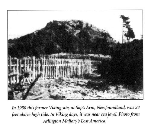
(Duane R. Aston, The Other Side of Cumorah, 2003, p. 38)
The reciprocal effect of the land shaking, splitting (along the Niagara Escarpment), and lifting in the (Jaredite) Land Northward, was a splitting of the earth (along the Onondaga Escarpment), and sinking of the land. This event created a tsunami wave effect causing much of the Sea South / Sea that Divides the Land (ancient Lake Tonawanda) to empty south into the Land Southward, creating a great deluge (for details see the following link).