Just Marlene Newell – Joseph Smith Model – Web site
“I became intensely interested in this subject while living in Provo, UT, and attending BYU. After reading several theories, I decided that I would find out for myself if the Book of Mormon provided enough information to precisely locate its key cities. This is the result of that effort.”
The H38 Virus has removed any mention of the Jaredite Land Northward on the site:
- Introduction
- The Joseph Smith Model
- Macro Mapping
- ZARAHEMLA’s borders and the River Sidon
- Bountiful and Manti
- Zarahemla and Gideon
- Minon, the hill Amnihah and the Wilderness Hermounts
- Melek, Ammonihah, and Noah
- Sidom
- Jershon and Antionum
- the Hill Riplah
- The wilderness near Ammonihah
- Moroni, Nephihah, and Aaron
- Lehi and Morianton
- Omner, Gid, and Mulek
- Cities in Jershon
- 2-Front Lamanite Invasion
- Capital Parts of ZARAHEMLA
- NEPHI’s Northern Border
- Zeniff’s Colony
- Alma’s Colony
- The Expedition to find ZARAHEMLA
- The Sons of Mosiah
- Lamanites become a cohesive society
- Nephite colonization of the land northward
The virus was so thorough, if one does a search for “Helaman 3:8,” it’s no where to be found.
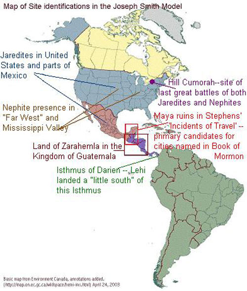
“In summary, these 21 articles provide the following six key identifications:”
- “the hill Cumorah in New York state is where the Nephites and Jaredites fought their last battles and where Mormon buried the plates “
- “the Jaredites occupied most if not all of present day United States and Mexico”
- “Lehi landed just south of the Isthmus of Darien”
- “the Land of Zarahemla was located in the former Kingdom of Guatemala”
- “the Maya Ruins in Stephens’ Incidents of Travel are primary candidates for cities named in the Book of Mormon”
- “the Nephites spread throughout the United States”
The H38 Virus removed the Seas South and North. Though this model may be congruent with statements made (or approved) by Joseph Smith, it bears little resemblance to the geography of the Book of Mormon.