Hamilton did a good job of identifying Ripliancum as the Sea North. He also placed it where it should be—north of Cumorah. However, like most, he did not pass the H38 Virus unscathed. The virus diluted the Sea North to the exclusion of all others.
The Book of Mormon tells us it means “large or to exceed all”. This description fits Lake Ontario perfectly. However we also need to consider that they may have been referring to the whole system of the Great Lakes. This body of water would have also been known to the Nephites as the North Sea Helaman 3:8.
Book of Mormon lands were only 1.5 days wide, and “limited” in size, something Mesotheorists understand. Although the Great Lake levels have fluctuated, the archaeological record dates back to Jaredite times in the areas that matter – specifically, the borders, where Lehi landed, the City of Bountiful, and the Land Northward, among others.
Other errors:

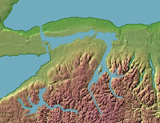
Relief Map – Western New York
It’s dishonest to claim this is a “relief map” as if it accurately reflects how the water looked. Like Book of Mormon models, this “relief map” has been altered to favor his/their interpretation. To accurately interpret the flow of water and the lay of the land, one must consult watershed maps. We use official watershed maps, and they do not support this artistic rendering. What’s more important, Hamilton/Olive trace the Narrow Neck to the east side of Book of Mormon lands, when it says it was on the west, with 1.5 days of land to its east, which is impossible in their model(s).
Having previously shown that Book of Mormon geography is anchored in western New York and using the information discussed above, makes it possible to identify the bodies of water that were nearly surrounding the land of Nephi and Zarahemla. By shading the Genesee River Gorge and the Lake Carl region in blue the east and south seas become apparent (see figure 2). As we observe Lake Ontario to the north, Lake Erie to the west, the old East Sea to the east and Lake Carl to the South we see a land nearly surrounded by water. According to Alma 22: 32 within this region lie the locations of the land of Nephi and Zarahemla.
The H38 Virus struck a blow and moved the true location of the Sea South to south of the lands Zarahemla and Nephi instead of south of the Jaredite Land Northward. Another modeler has failed the test.
This is not to say that the Nephites and Lamanites did not spread out across the American Continent. Every indicator suggests that they did – but the Book of Mormon contains the history of those who lived in a specific area between the east sea and the west sea that were about 40 miles apart in western New York – see Alma 22:32 below. Additionally all of the history occurs in a localized region in and around Zarahemla.
More confusion and double-speak. On the one hand, Hamilton says Book of Mormon lands were small, but on the other, he claims their people spread “across the American continent.” He goes on to claim the prophecies of the Book of Mormon were fulfilled by the United States, but fails to isolate “when” they were. Colonial America is “when” all land prophecies were fulfilled, which excluded Missouri. On Hamilton’s Bibliographical listing are several titles related to the Hopewells. By this, we conclude that he wants to respect the text, but is unable to let go of old Hemispheric concepts.
Book of Mormon lands were hidden, isolated, and small.