Bio
Joseph L. Allen earned his Ph.D. from Brigham Young University in Ancient and Modern Scripture with an emphasis in Mesoamerica and the Book of Mormon. A popular teacher and lecturer, Dr. Allen served in the Church Educational System for 18 years. Joe and Rhoda have lived in Utah, Idaho, Arizona, Texas, Chihuahua, Mexico City, Guatemala City, and Spain while serving on Church assignments or pursuing business endeavors. They have seven children (one deceased) and a bunch of grandchildren and are starting on great-grandchildren. Joe was teaching a gospel doctrine class when he met Rhoda. He is teaching a gospel doctrine class now–just not in the same ward. Administrative callings have interrupted his teaching from time to time.
Dr. Allen has authored the best selling books Exploring the Lands of the Book of Mormon and Sacred Sites, which present detailed analyses and studies of discovered archaeological finds with proposed Book of Mormon sites. In addition, he has authored and contributed to many articles, books, CD’s and DVD’s:
Allen, Joseph L. A Comparative Study of Quetzalcoatl, the Feathered-Serpent God of Meso-America, with Jesus Christ, the God of the Nephites. Dissertation, Brigham Young University, 1970
Allen, Joseph L. Exploring the Lands of the Book of Mormon. Orem, UT: S. A. Publishers, 1989
Allen, Joseph L., Ed. Book of Mormon Archaeological Digest, 1992-2009. Published by Book of Mormon Tours. Quarterly articles and Internet articles on Book of Mormon history, language, culture, and geography
Allen, Joseph L. Proposed Map of Lands of the Book of Mormon. Gateway Publishing, 1998
Allen, Joseph L. Sacred Sites: Searching for Book of Mormon Lands. American Fork, UT: Covenant Communications, 2003
“Land of and City of Bountiful,” “Land of and City of Nephi,” and “Quetzalcoatl.” In Dennis L. Largey, gen. ed. Book of Mormon Reference Companion. Salt Lake City: Deseret Book, 2003
Brinkerhoff, Val and Joseph L. Allen. Visualizing the Book of Mormon. American Fork, UT: Covenant Communications, 2007
Allen, Joseph L. with Chris Heimerdinger. Lehi’s Land of First Inheritance. New Light Publications and Book of Mormon Archaeological Foundation, DVD
Allen, Joseph L. and Blake J. Allen, Exploring the Lands of the Book of Mormon, 2nd ed. Orem, UT: Book of Mormon Tours and Research Institute, 2008
Allen, Joseph L. and Blake J. Allen. Exploring the Lands of the Book of Mormon, 2nd ed., CD. Orem, UT: Book of Mormon Tours and Research Institute, 2008x`
Editorial Reviews
The Allens are among the most accomplished teachers and educators in the field of Book of Mormon history and geography. In our opinion, the second edition of Exploring the Lands of the Book of Mormon will be the encyclopedia for the study of the Book of Mormon history and geography for years to come. –Thomas and Jennifer Ferguson
The first edition [of Exploring the Lands of the Book of Mormon] was published in 1989 and has been an overwhelming success. It has sold over twenty-five thousand copies in fifteen printings and was the principal text used by Dr. Bruce Warren in his Brigham Young University course on archaeology and the scriptures. Its attention to detail and its descriptive maps and adherence to sound research principles have made it the authoritative reference on Book of Mormon geography, culture, and history for the past nineteen years. Yet even as the first edition was being published, new discoveries, insights, and ideas regarding the historical setting of the Book of Mormon were being presented. And although the final chapter on Book of Mormon culture will likely not be written for many years to come, the second edition of Exploring the Lands of the Book of Mormon is undoubtedly the most thorough text published on this subject to date. —Dr. Brent J. Allen
About the Author
Dr. Joseph Lovell Allen, educator, author and explorer, is a pioneer in the study of history and geography of Mesoamerica and the Book of Mormon. He has spent almost fifty years in teaching, searching and researching the internal and external messages of that sacred history revered by millions of Latter-day Saints worldwide. Blake Joseph Allen is the president of Book of Mormon Tours and Research Institute, and a respected guide who has led thousands of visitors through Mesoamerica. His professional work has given him key insight into the language, archaeology, customs, history, and geography of the ancient inhabitants of Mesoamerica and how these items correlate with information in the Book of Mormon.
(Source: Amazon, Joseph Lovell Allen and Blake Joseph Allen (Author), Ted D. Stoddard (Editor), Various (Illustrator), Exploring the Lands of the Book of Mormon, 2008, http://a.co/6Go2PTE)
Introduction
Perhaps no other book on Book of Mormon Geography has received as wide attention as Dr. Allen’s Exploring the Lands of the Book of Mormon. It was widely marketed in Church bookstores and by professors at BYU, where thousands of students used his books in their classes. Normally, the highlights of one’s bio are items to be fondly remembered and recognized. In it, Dr. Allen lists two editions, fifteen or more printings, fifty years of teaching, and dozens of tour groups over several decades to Peru and Mesoamerica, among other accomplishments. These things can be applauded unless the person had their ladder against the wrong wall, which is the case with Dr. Allen (but he’s in good company—if that’s of any consolation).
Culture -v- Fulfilled Land Prophecies
Dr. Allen admittedly came into the field of BOMG from the cultural viewpoint rather than the geographical (though some may insist they go hand-in-hand):
My personal battle has followed the circuit from embracing Book of Mormon external evidences to ignoring any geographical model (Chapter 16).
After embracing the BOMG, Dr. Allen kept his cultural interests high on his list:
I have felt that the geography should be studied in conjunction with archaeological evidence, language associations, and cultural and traditional patterns.
Dr. Allen should be commended for arriving at a “two or three witness criteria” for establishing his BOMG:
From that time forth, I have always tried to be true to two or three-witness criteria. This statement simply means that if we make a Book of Mormon geographical hypothesis, we ought to test that hypothesis against the archaeological, cultural, and traditional history of the area. In the absence of these two or three witnesses, I feel that we stand on rather shaky ground.
While we might agree with his 2 or 3 witness approach, we do not agree with his proposed data sets (archaeology, culture, and traditional history) because both Jaredite and Nephite cultures were methodically erased:
14 For at the present our strugglings were vain in restoring them to the true faith. And they swore in their wrath that, if it were possible, they would destroy our records and us, and also all the traditions of our fathers. (Enos 1)
It should be understood that the language and culture approach is faulty at its premise in that it is presumed to have survived! Their enemy knew the prophecies that said one day their records would come forth to convert their descendants. This is what fueled the last Lamanite scorched-earth campaign that led to the final Nephite battle:
5 But it came to pass that whatsoever lands we had passed by, and the inhabitants thereof were not gathered in, were destroyed by the Lamanites, and their towns, and villages, and cities were burned with fire; and thus three hundred and seventy and nine years passed away. (Mormon 5)
It should also be understood that there were pre-existing people, i.e., “Lamanites by birth,” who existed in and around the Land of Nephi and had their own language and culture before Lehi arrived (and continued after the Nephites were destroyed):
4 And he appointed teachers of the brethren of Amulon in every land which was possessed by his people; and thus the language of Nephi began to be taught among all the people of the Lamanites. (Mosiah 24)
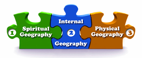
The only language or culture one could hope to find 1,500 years later would be the pre-existing Lamanites (i.e., by birth), not the Nephites. A better choice of data sets would be: fulfilled land prophecies, i.e., the Spiritual Geography, the Internal Geography, and Physical Geography—the PSI of Book of Mormon Geography:
Peru
Dr. Allen originally believed and taught that Peru was the heart of Book of Mormon lands and took many tours there:
I have escorted hundreds of Latter-day Saints on tours from New York to Peru.
Under the tutelage of the head of the archaeology department of BYU (Dr. Wells Jakeman), Dr. Allen changed his position and abandoned Peru altogether, which makes Dr. Allen one of the few modelers to admit they were wrong:
I subsequently eliminated Peru as the heartland of the Book of Mormon, since the archaeological evidence is minimal and the linguistics evidence is nil when compared to Mesoamerica.
It must have been a thrill for him at the time to approach Machu Picchu with his group and exclaim: “Behold Zarahemla” (or similar).
Approach
Dr. Allen should be admired for making the following statement:
Any study of the Book of Mormon geography must strictly adhere to criteria that do not alter the Book of Mormon text, the proposed map, nor established scientific dating systems. The location of lands, oceans, rivers, mountain ranges, and boundaries in relationship to distances and relative positions in the Book of Mormon MUST MATCH.
But he should be confronted for not following his own advice!
Location of Lands
In the first example, we will point out that Dr. Allen purposely ignored the many Church statements that placed the final Nephite battle in Palmyra, NY. He acknowledged the later statements by Joseph Smith in the Times and Seasons article, which claimed the ruins in Central America were of Book of Mormon origin, but ignored Joseph’s earliest statements. There were two different “Josephs,” the first was given when he was walking right with God; the latter when he wasn’t.
By respecting the early statements of Joseph and others regarding the location of the final Nephite battle, all Book of Mormon lands could have been traced in western New York. However, because he ignored those statements, he has spent his life on a wild goose chase.
In his Survey of Geography, Dr. Allen conveniently omitted the work of Willard Bean, who facilitated the purchase of the Hill Cumorah for the Church and authored several books.
The Geography of the Book of Mormon by Cecil McGavin and Willard Bean, 1948.
From the Preface,
“In recent years there has been a tendency among certain students of the Book of Mormon to orientate Book of Mormon cultures far to the south.”
“For many years the Book of Mormon carried footnotes explaining that ‘the land of many waters,’ ‘the large bodies of water,’ ‘Ripliancum,’ etc., had reference to the Great Lakes, while Ramah and Cumorah were the identical hill, near Palmyra, New York.”
“The following pages are a PLEA in defense of the old theory – the interpretation of Joseph Smith, Oliver Cowdery, Orson Pratt, and a countless number of the Authorities of the Church. It is our humble opinion that THERE IS NO OCCASION TO FLING ASIDE THE OLD INTERPRETATION AND ACCEPT THE NEW.”
From the Conclusion,
“The accounts written by many of these reputable historians and archeologists are so clear and specific that it seems as if the authors were familiar with The Book of Mormon record of the wars of extermination that were waged in Ramah-Cumorahland. For more than two centuries these renowned scholars have designated this area as America’s greatest battlefield in ancient times. Their conclusions agree so faithfully with The Book of Mormon record that WE NEED NOT LOOK ELSEWHERE for the solution of the mystery.”
“Middle America is not a land of many waters. Its ancient hills are not marked with tokens of fortification; its skeptical remains do not tell of a bitter war of extermination, comparable at all to the evidence in Western New York.”
Or the work of Dr. Duane Aston,
Return to Cumorah by Duane Aston, 1998
We could include the masterful discourse by President Joseph Fielding Smith and his list of exclusions, but we will instead refer readers to the 20+ statements by Church leaders on our Cumorah page to see what Dr. Allen left out.
Location of Seas
Let’s recall the standard of research Dr. Allen said researchers should abide by:
Any study of the Book of Mormon geography must strictly adhere to criteria that do not alter the Book of Mormon text, the proposed map, nor established scientific dating systems. The location of lands, oceans, rivers, mountain ranges, and boundaries in relationship to distances and relative positions in the Book of Mormon must match.
Unfortunately, Dr. Allen did not give heed to his own advice and ignored the references to a North Sea and South Sea surrounding the Jaredite Land Northward. His model (like most) is entirely void of four distinct seas surrounding the Land Northward:
The reference to four seas is here:
8 And it came to pass that they did multiply and spread, and did go forth from the land southward to the land northward, and did spread insomuch that they began to cover the face of the whole earth, from the sea south to the sea north, from the sea west to the sea east. (Helaman 3)
Further support for a Sea North is here: www.bookofmormongeography.org/seas/sea-north/; for the Sea South is here: www.bookofmormongeography.org/seas/sea-south/; and refutes against the view that it’s just a metaphor here: www.bookofmormongeography.org/basics/models-reviewed/h38-virus/.
Many other deficiencies could be cited. One example is his whitewashing of history to try and show the Church never supported a particular geography. He failed to mention that the Church not only funded, but the First Presidency approved, the film Ancient America Speaks (1972). This movie was used for decades in the church by tens of thousands of missionaries, and it cleverly tried to tie the discoveries in Mesoamerica to the Book of Mormon, or his support for the now disproven association of Izapa Stela 5 with the Tree of Life of Lehi’s vision, or Quetzalcoatl as Jesus Christ.
Internal Map
Because early modelers did not extract the Internal Geography nor plot land distances, they, like Dr. Allen, filtered what the text said according to whichever physical piece of land they had in mind, placing the cart before the horse—a bias Dr. Allen readily admitted:
My approach, which will be followed in this book, has the objective of analyzing each geographical statement in the Book of Mormon in relation to the geographical and historical structure of Mesoamerica.
While Dr. John Clarke and John Sorenson espoused the worth of an Internal Map, Dr. Allen did not:
It may seem noble to present only the internal geographical structure of the Book of Mormon on a make-believe map, but doing so seriously hampers an understanding of the Book of Mormon.
That statement contradicts his earlier statement:
In my opinion, the Book of Mormon provides adequate detailed information to draw some geographical conclusions. Indeed, Mormon seemed to write as if we had a map in front of us.
Had Dr. Allen first drawn an Internal Map, he would have had a Land Northward surrounded by four seas, which would have precluded any areas south of western NY because of where Joseph said the final Nephite battle took place.
Narrow Neck & Passage
Most read the “1.5 day wide” verse as referring to the width of just the Narrow Neck instead of the width of Book of Mormon lands. Without the Mesoamerican filter, a reader can clearly see it’s referring to the entire width of Book of Mormon lands:
Thus, the land on the Northward was called Desolation, and the land on the Southward was called Bountiful.
And now it was only the distance of a day and a half’s journey for a Nephite on the line Bountiful and the land Desolation from the East to the West Sea.
And thus, the land of Nephi and the land of Zarahemla were nearly surrounded by water, there being a SMALL NECK OF LAND between the Land Northward and the Land Southward. (Alma 22:31-32)
The Land Southward was “nearly surrounded by water” because it only had three seas around it. The word “narrow” from eye level (like Mormon had, not a map view from space) would be a width in feet or yards, not miles, which we commend Dr. Allen for figuring out:
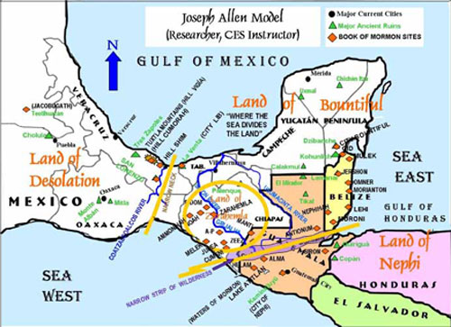
Sorenson creates a narrow pass along the top of the Gulf of Mexico. Allen sees the Narrow Neck/Narrow Pass as running between two mountain ranges. Sorenson’s Narrow Neck is a distance of 125 miles long. Allen’s Narrow Pass is about 100 yards at its narrowest point.
Condemnation
Perhaps the biggest surprise with Dr. Allen was his subconscious awareness that the field of BOMG was being hampered by the Church-wide curse of darkened minds. This is how he ended his Survey of Geography:
On November 10, 1985, Ezra Taft Benson was set apart as Prophet, Seer, and Revelator and President of The Church of Jesus Christ of Latter-day Saints. In his first General Conference address as President, in April 1986, he vividly proclaimed the importance of the Book of Mormon with strong words that continue to this writing:
“Unless we read the Book of Mormon and give heed to its teachings, the Lord has stated in Section 84 of the Doctrine and Covenants that the whole Church is under condemnation: ‘And this condemnation resteth upon the children of Zion, even all.’ (D&C 84:56) The Lord continues: ‘And they shall remain under this condemnation until they repent and remember the new covenant, even the Book of Mormon and the former commandments which I have given them, not only to say, but to do according to that which I have written.’ (D&C 84:57)
Now we not only need to say more about the Book of Mormon, but we need to do more with it…I promise you that from this moment forward, if we will daily sup from its pages and abide by its precepts, God will pour out upon each child of Zion and the Church a blessing hitherto unknown – and we will plead to the Lord that He will begin to lift the condemnation – the scourge and judgment. Of this I bear solemn witness” (Benson, “A Sacred Responsibility” p. 78).
It is awkwardly apparent to us that this sadly is the case. Having separated from the Church due to this Church-wide curse, we received the promised “blessing hitherto unknown,” which in part is the true geography of the Book of Mormon. What is different can be read here: