Commencing at the southern shores of the northern lakes [Erie & Ontario] and extending southward a hundred miles or more we find a greater number of MILITARY WORKS [fortifications] than in any other section of the United States.
It is my opinion that the terrible conflicts which produced such a GREAT NUMBER of FORTIFICATIONS as we find in Western New York, were instigated by superstition which, with all nations and peoples, is the fountain head of WAR and CRUELTY. It seems impossible that a people conditioned as they must have been would have spent SO MUCH LABOR in building such monuments and FORTIFICATIONS that have resisted the action of the elements for perhaps thousands of winters unless they were FIRED by a veneration for some TERRIBLE SUPERSTITION, or for the DREAD MINISTERS by whom it was interpreted (Frederick Larkin, M.D., Ancient Man in America, 1888, pp. 71-72).
Buffalo logged more days of 50% sunshine than Orlando, FL (Mike Vogel, “Buffalo is Sunshine Capital of Northeast,” Buffalo News, May 18, 1989, A-1).
In sum, there are no studies that have addressed the regional problem of the function(s) of the earth-work sites in a systematic fashion. Information about individual sites is largely unpublished, and existing collections have not been analyzed to address issues of site function… Careful, independent assessment of archaeological data has yet to be done (“Reanalyzing the Ripley Site: Earthworks and Late Prehistory on the Lake Erie Plain,” ed. Lynne P. Sullivan, New York State Museum Bulletin, no. 489, The State Education Department, 1996, pp.15-16).
That which preceded [the Iroquois] was either blotted out or swallowed up (Arthur C. Parker, The Origin of the Iroquois as Suggested by Their Archeology, 1916, p. 481).
Mounds in New York have had no systematic examination despite the large amount of work done by amateurs in excavating them. It is safe to say that the possibility of making a methodical examination is now reduced by two-thirds, through the vandalism of inexperienced relic hunters. Many mounds have been scraped down merely to level the ground and others have been scraped into by spade and horse scraper to find what ‘valuables’ they might contain. Few records have been kept and not all that have been made are reliable (Arthur C. Parker, “The Archeological History of New York,” New York State Museum Bulletin, nos 235, 236, July-August 1920, Albany, p. 87).
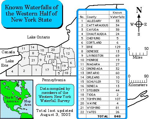
Western New York is truly a land of many waters, containing nearly 900 waterfalls:
The Western New York model encompasses Western New York during the “Middle Woodland Period” [500 BC—AD 1000], and is of the Point Peninsula Complex and Squawkie Hill phase.

To be considered a Western New York model, it must meet two criteria:
- Mirror the Holland Land Purchase
- Not extend beyond Colonial America
Western New York is Unique
First and foremost, it was populated with defensive forts, where they should be, and in the correct manner, and lacking them where they should not be.
The great amount of copper implements and blocks of mica, that have been found, contradicts the theory of Mr. Squier that the tumuli located in Western New York are not the work of the Mound-Builders. I am satisfied, beyond a doubt, that the Indian races [Iroquois Nation] never mined for mica or copper, neither did they bury either of these articles with the remains of their distinguished dead (Frederick Larkin, M.D., Ancient Man in America Including Works in Western New York and Portions of Other States, 1880, p. 19).
The fact that Mr. Squier, after making some personal examinations of a few of the works in Western New York, has pronounced them the works of Indians [Iroquois Nation], has had great weight with modern investigators who have adopted that theory (Larkin, p. 62).
Notwithstanding the Iroquois were the most powerful and intellectual people north of the Montezumas, and that they displayed great energy, especially in war, and held much of the territory in eastern and central New York, I can learn of no mounds or military fortifications similar to those found in Western New York or that section lying between the southern shores of Lakes Erie and Ontario and the head waters of the Allegany River. No nation of Indians within the records of history has ever built structures that would stand the ravages of the time that has passed away since the foundations of many of the works located in Western New York have been laid (Larkin, p. 63).
It is admitted by all of the intelligent Iroquois with whom I have conversed, that the people who constructed the mounds were an unknown people, and that tradition interposes no beams of light to extricate them from the confusion which has been wrought by time (Larkin, p. 64).
The evidences of mound culture are more numerous in extreme western New York than east of the Genesee river (The Genesee River/Gorge, the “Grand Canyon of the East” was the East Sea). [TRUE] The culture seems to have entered the State along the shores of Lake Erie and up from the Allegheny river. Chautauqua, Erie and Cattaraugus counties thus contain a larger number of mounds than do other portions of the State, though certain other sections, as the Genesee valley, have yielded relics in abundance (Arthur Caswell Parker, Archeological History of New York, vol. 1-2, 1922, p. 9).
In 27 counties some form of mound has been reported and a summary of these follows. They are most frequent west of the center of the State (William M. Beauchamp, “Perch lake mounds, with notes on other New York mounds, and some accounts of Indian trails,” New York State Museum Bulletin, 87, Archeology 10, 1905, p. 25).
From the appearance of the mounds and their location and mode of construction found in Western New York, I am led to believe that at the time those cruel and devastating wars were waged the assaulting party came from the south [TRUE] and it is not improbable that there might have been a northern and a southern confederacy, [TRUE] and that policies might have been in some way connected with it (Larkin, p. 75).
Second, it has the correct width, where the width is given.
Third, it is the correct length, where the length is given.
Fourth, it has water where water should be (or evidence of how it was anciently) and how it should be with rivers, waters and seas.
Fifth, it has a Narrow Neck where the Narrow Neck should be.
Sixth, the terrain is as it should be, where it should be, with plains, mountains, valleys, hills, and harbors.
Seventh, it has timber, including the types used for houses, temples, and ships, where they should exist, and in adjacent areas where they could find timber.
Eighth, it has cement where cement should be and lacking it where it should not be.
Ninth, it has unique features that make it “choice” above all other lands, like a water filtration system, a gravity-fed irrigation system, continuous lighting, rich soils with plenty of precious metals, minerals, and multiple fuel sources.
Tenth, land prophecies were fulfilled there including the changes that occurred at the coming of Jesus, the land becoming inhabited by multitudes of white Gentiles, the ownership of the land switching to the Gentiles, the Gentiles founding a new government with the Indians, that new government becoming a New Jerusalem, a land of liberty, without a king; becoming greater than all nations of the earth, a blessing to all nations of the earth, and a supporter of the restoration of the House of Israel, the establishment of the State of Israel.
Eleventh, a land that was filled with the Spirit of God, visits by Jesus, a state of doctrinal confusion, and the place of the deposit and retrieval of the Nephite record.
Twelfth, the land where the mother countries of the Gentiles came to make war, by land and sea, against the Gentiles.
Thirteenth, the place where the power of God came down with miracles in support of the Gentiles.
I am persuaded that enough has been said to demonstrate the existence of a vast population, settled in towns, defended by forts, cultivating agriculture, and more advanced in civilization than the nations which have inhabited the same countries since the European discovery (Governor De Witt Clinton, Memoir on the Antiquities of the Western Parts of the State of New York, 1820, p. 14).
Further Reading
- Memoir on the Antiquities of the Western Parts of the State of New York by Governor De Witt Clinton in 1820
- Pioneer History of the Holland Purchase of Western New York by O. Turner in 1850
- Ancient Man in America Including Works in Western New York and Portions of Other States, by Frederick Larkin, M.D. in 1880

Prehistoric People of Western New York [Jaredites, Nephites, Mulekites, and Lamanites]

The War of 1812 on the Frontier [“I beheld that their mother Gentiles were gathered together upon the waters, and upon the land also, to battle against them” (1 Nephi 13:17) ]

The Village of Buffalo 1800-1832 [ancient City of Bountiful]

Peter B. Porter and the Buffalo Black Rock Rivalry [Black Rock Pier was used by Hagoth]

The Grand Canal New York’s First Thruway [brought the Smiths to Palmyra, by the Hill Cumorah]

Western New York Heritage Magazine

Remembering Niagara: Tales from Beyond the Falls by Robert Kostoff
Under the spray of the majestic Niagara Falls, the Iroquois built a nation, the War of 1812 raged and newly married couples honeymooned. In Remembering Niagara, local journalist Bob Kostoff has collected the best of his Nuggets of Niagara County History column, first published in the Niagara Falls Reporter, documenting the county’s history from its early settlers through later engineering marvels. Among the stories are tales of the mysterious early mound builders and a kite-flying youngster who played a key role in the engineering of the first suspension bridge across the Niagara gorge (Amazon Book Description).